Finding HMAS Sydney (II)
Scope of work
The following is an excerpt from Section 1.4 of the Final Report.
Williamson & Associates Inc (W&A) of Seattle, USA, was contracted to the FSF to provide deep-water side scan sonar equipment and personnel to find the Sydney and Kormoran wrecks off Shark Bay, Western Australia in depths of approximately 2,000m to 4,000m.
DOF Subsea Australia Pty Ltd ("DOF") of Perth, Western Australia, was contracted to provide the Geosounder with navigation equipment, a remotely operated vehicle ("ROV") and marine, survey and ROV personnel to undertake a search for, and subsequently complete a visual inspection of, the wrecks.
The objectives of the project were to search for and locate the above-mentioned wrecks by sonar imaging, and thereafter with the aid of an ROV, provide absolute confirmation of the wrecks through photographic and video images.
The side scan sonar survey plan was provided by the Search Director, Mr. David Mearns, of Blue Water Recoveries Ltd. This plan was based on the research undertaken by David Mearns prior to the commencement of the offshore survey operations as detailed in Section 1.3.
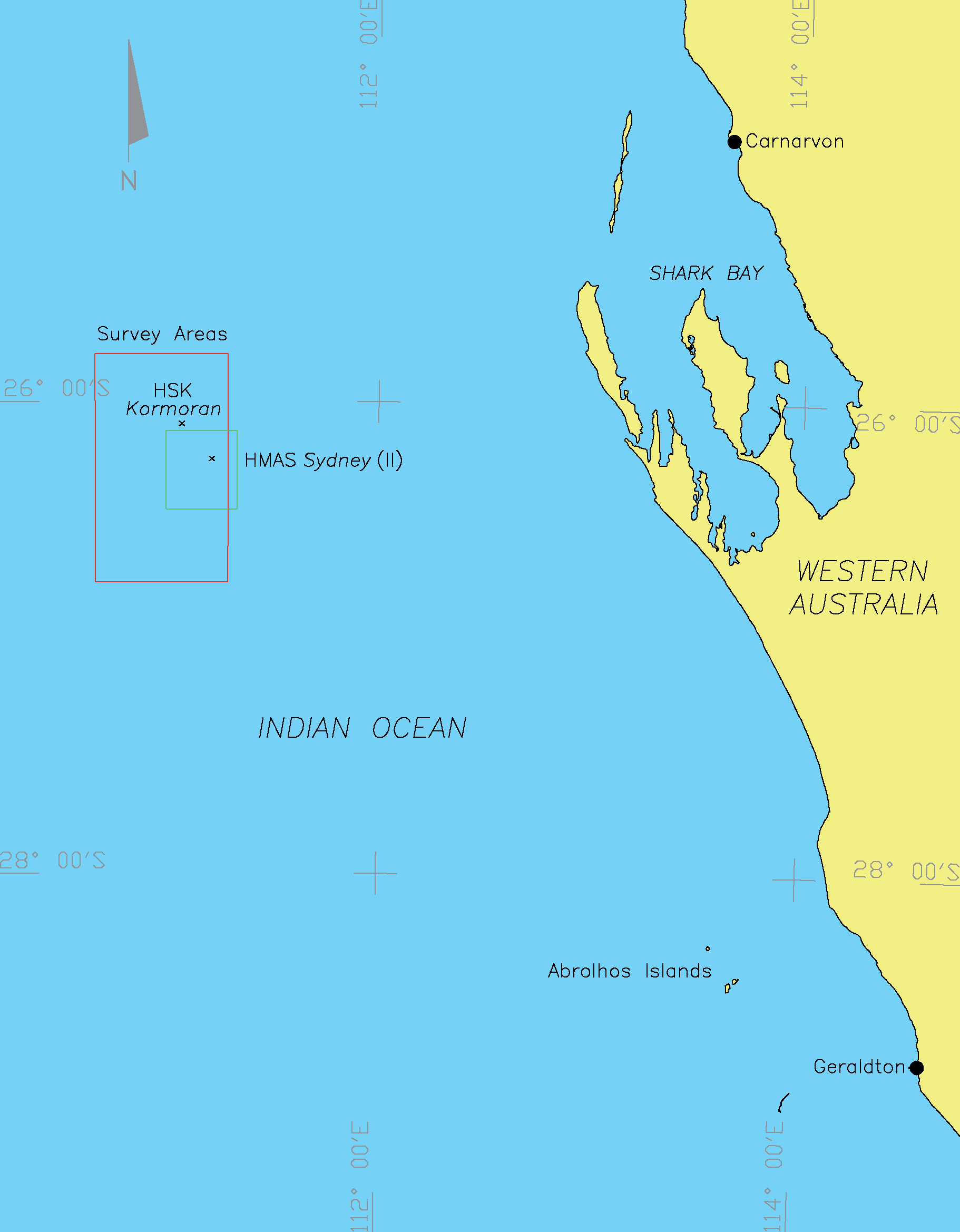
The sonar survey search area for the Kormoran wreck was to cover an initial rectangular area of approximately 69km x 108km bounded by the coordinates provided in Table 1-1.
| Corner | Latitude (S) | Longitude (E) |
|---|---|---|
| NW Corner | 25° 48' 00" | 110° 40' 00" |
| NE Corner | 25° 48' 00" | 111° 17' 30" |
| SW Corner | 26° 46' 00" | 110° 40' 00" |
| SE Corner | 26° 46' 00" | 111° 17' 30" |
Proposed survey run-lines for the initial search site comprised 12 parallel, north/south oriented primary lines, approximately 110km in length, at a nominal line spacing of 5,000m. Line spacing was, however, reduced after survey operations commenced due to a reduction in usable sonar swath from the W&A equipment.
On finding the Kormoran wreck site a second, smaller search area of approximately 37km x 37km was to be surveyed to search for the Sydney wreck. The Sydney site boundary coordinates are provided in Table 1-2.
| Corner | Latitude (S) | Longitude (E) |
|---|---|---|
| NW Corner | 26º 07’ 30" | 111º 00’ 00" |
| NE Corner | 26º 07’ 30" | 111º 20’ 00" |
| SW Corner | 26º 27’ 30" | 111º 00’ 00" |
| SE Corner | 26º 27’ 30" | 111º 20’ 00" |
An ROV inspection survey was to be undertaken to confirm the two wreck sites to be that of the Sydney and Kormoran and confirm their position, if water depth were favourable.
A survey location diagram is presented as Figure 1-1.